1920’s to 1940’s |
In the 20th century some of the coastal villages were becoming popular as summer “resorts”, particularly for people in Aberdeen to escape the city for the day. Muchalls, in particular, was a popular destination for people from Aberdeen, and from farther afield. Occasionally some of the old fishing dwellings were bought and turned into holiday homes. Unfortunately the villages of Downies, Portlethen and Findon didn’t share in this “leisure” boom, a telling factor possibly being the distances that these villages were located from a main railway station, each village being, at least, a good one mile walk from the nearest station.
 The
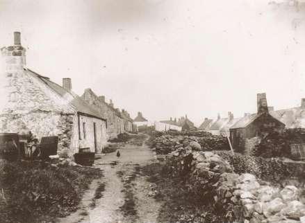
author, Peter Anson, noted in the 1920’s, that Downies was “a near
derelict village consisting of a few whitewashed houses and the ruins
and foundations of a good many more”. At that time, there was a small
narrow path leading to the edge of the cliff and then descending to a
tiny cove, sheltered by rocky headlands. Anson further notes that there
were no more than eight boats in the
The
author, Peter Anson, noted in the 1920’s, that Downies was “a near
derelict village consisting of a few whitewashed houses and the ruins
and foundations of a good many more”. At that time, there was a small
narrow path leading to the edge of the cliff and then descending to a
tiny cove, sheltered by rocky headlands. Anson further notes that there
were no more than eight boats in the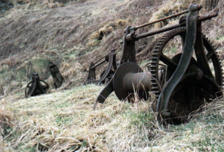 shore, most of which were rotting
away, and all of them pulled well up the grassy bank. Referring to his
sketch you can see how the shore looked in the 1920’s and you can also
note the primitive wooden slipways that were used to prevent the boats
from being damaged on the rocks. Today Downies looks much the same, with
the narrow path, the tiny cove and the rocky headlands; all that’s
missing are the boats and slipways. If you do follow the path down into
the shore you will notice some remnants of the past in the presence of
two or three redundant and rusting iron winches on the grassy slopes
near to the path, you may also see some iron pins hammered into rocks on
or near the shore itself, all these things indicative of the haven of
industry that this used to be in the 1800’s.
shore, most of which were rotting
away, and all of them pulled well up the grassy bank. Referring to his
sketch you can see how the shore looked in the 1920’s and you can also
note the primitive wooden slipways that were used to prevent the boats
from being damaged on the rocks. Today Downies looks much the same, with
the narrow path, the tiny cove and the rocky headlands; all that’s
missing are the boats and slipways. If you do follow the path down into
the shore you will notice some remnants of the past in the presence of
two or three redundant and rusting iron winches on the grassy slopes
near to the path, you may also see some iron pins hammered into rocks on
or near the shore itself, all these things indicative of the haven of
industry that this used to be in the 1800’s.
Anson also noted that the village of Portlethen, although not so derelict or decayed as Downies, had also suffered decline over the previous decades. Quoting directly from his book (still in the 1920’s), here is what Anson had to say about Portlethen:
“A path leads down from the village to a cove which
affords shelter for boats except when the wind is from the south east.
The beach is not very wide, and as will be seen from my drawing, the
same system for hauling up boats is in use here as at Downies. To-day a
few elderly men fish for crabs or lobsters in the four small craft that
are left in Portlethen. Thirty years ago you would have found seven or
eight yawls here; twenty years before that, no less than eighty nine
fishermen and thirty seven boats. It is difficult to realise how room
can have been found for such a number in this tiny bay!”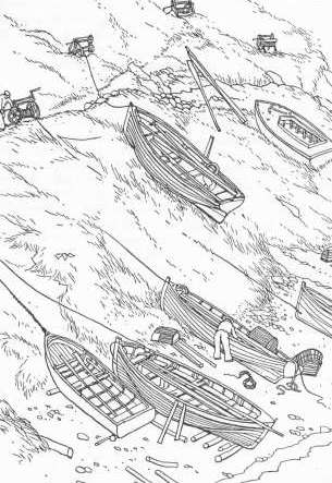
Our third village, Findon, stopped being a proper fishing village many years before the other two. The “Finnan Haddie” had long since disappeared and the shore there was never a good natural harbour, being very narrow with a precipitous climb to get to the “brae head”.
The location of the village of Findon differs in its topography from those of Downies and Portlethen in that it is not a cliff top village and is set well back from the coast. The people of Findon have a walk of around half a mile to get to their local shore and possibly this small detail hastened the village’s demise as a fishing village. Ironically perhaps, Findon didn’t suffer the same amount of dereliction and ruin as the villages of Downies and Portlethen and although the fishing fraternity moved away it would appear that they were replaced by others and most of the original houses were used and developed rather than being left to fall into dereliction.